Details of the paper by Bi and Li (2004) concerning the US Library of Congress Qing Period Scroll Map of the Shu Road.
|
|
|
中文:
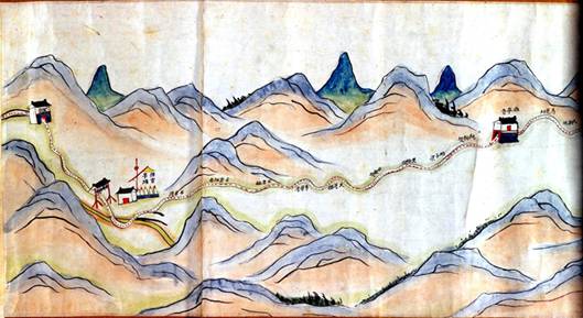
《陕境蜀道图》研究 毕琼 李孝聪 (作者) 地图2004(4),页45 摘要: 美国国会图书馆藏有一轴清人所绘地图,不具图名、绘者、内容是描绘自宝鸡县城出发,经大散关走连云栈到达留坝,再经褒城、沔县、宁羌州直达陕蜀边界七盘关这一翻越秦岭的道路走向及沿途景致。其中褒城至沔县之间的部分图幅缺佚。由于地图所反映的主要是自陕入蜀的一段道路沿途,故定名为《陕境蜀道图》。 (共6页)
|
|
English:
Bi, Qiong and Li, Xiaocong (2004). Research into “The Shu Road from Shaanxi to the Sichuan Border”. Cartography (China, in Chinese), 4, 45- Abstract: The US Library of Congress collection holds a Qing period painted scroll map for which the main purpose and author are unknown. The map depicts a journey starting from Baoji (then a county), through the Dasan Pass to connect with the Lianyun road and arrive in Liuba. It continues on to Baocheng, Mianxian, Ningqiangzhou and to the Shaanxi-Sichuan border at Qipan Pass. It depicts the road through the Qinling mountains and the scenery along the way. A section between Baocheng and including Mianxian is missing. The most important aspect of the map is that it provides a useable map of the road from Shaanxi to Sichuan. Its ancient name is: "The Shu Road from Shaanxi to the Sichuan Border". (Paper has 6 pages)
A PDF for a Draft English Translation of this paper can be found here
Web Site for paper: Bi_Li_LOC_Scroll_Paper_I.pdf |
|
Pinyin:
“Shan jing shu dao tu” yan jiu Bi Qiong & Li Xiaocong Ditu, 2004(4), ye 45 Zhaiyao: Meiguo Guohui Tushuguan you yi zhou Qingren suohui ditu, buju tuming, huizhe, neirong shi miaohui zi Baoji Xian Cheng chufa, jing Dasanguan zou Lianyun daoda Liuba, zai jing Baocheng, Mianxian, Ningxiang Zhou zhida Shanshu bianjie Qipanguan zhe yi fanyue Qinling de daolu zouxiang ji yantujingzhi. Qizhong Baocheng dao Mianxian zhijian de bufen tufu queyi. Youyu ditu suo fanying de zhuyao shi zi Shan ru Shu de yi duan daolu yantu, gu dingming wei "shan jing shu dao tu". (gong 6 ye)
Wangzhi: Bi_Li_LOC_Scroll_Paper_I.pdf |