|
The Chinese name for Australia
INTRODUCTION
The document with the name above, which is described,
summarised and made available in this page is not about
Plank Roads.
It is a document put together by David Jupp in response to some apparently
simple questions that arose from seeing a Chinese map a number of years previously.
When time came to look for the answers, the questions turned out to be
anything but simple. But the places the enquiry journeyed were interesting (to
DLBJ at least) as well as involving reading books in Chinese and English and Chinese by English,
exploring the internet in two languages, visiting the
Asia Bookroom and the
National Library
Asian Reading Room
and prompting
many other excursions of the mind. It concerns the change in outlook among scholar-officials in
late Qing China (1800-1860) that was made necessary by the aggressive actions of
western “Maritime Nations” leading to the Opium Wars, the Unequal Treaties,
Treaty Ports and the Taiping Rebellion. Between 1840 and 1850 Qing China’s
recorded geography and history of the western nations, knowledge about the changed circumstances
in the Nanyang and the existence of established British colonies in the
newly named “Australia” became established. On the positive side, when Gold was
discovered in North America and Australia it was not in unknown places and
the its locations could generally be found on a Chinese map - or at least on a map in Chinese.
DISCLAIMER
Although much of this is
historical, I am not a historian and so the best standards of academic history may
not always have been met. It is a personal interest with my only professional standing
being my interest in maps and mapping and my profession in a modern branch
of this activity. The document is a record of what I found and leaves little
out that I thought useful or interesting. To reduce the volume of words in the main story, I put a
lot of material into Endnotes – rather than leave it out. During my activity,
I changed course a few times and the traces of the previous courses and
the final course all contribute to its final structure. If this makes some
passages harder to understand, I apologise. Finally, I have used
illustrations that are mostly (I think) out of copyright and in the few cases
where they may not be I have put in something I found as a place holder.
In this aspect, the document is still to be regarded as a
draft as the figures are not yet all acknowledged and not all permissions
yet sought. If, despite all this, you still wish to read it you are very welcome but
asked to keep the above in mind. Whatever the result of all these provisions,
you are welcome to continue and read the following summary which is a lot shorter than
the complete compendium. ☺
SUMMARY OF THE MOTIVATING QUESTIONS:
The Chinese name for Australia has four characters (澳大利亚) and is written in Pinyin
and pronounced using Mandarin (or “Putonghua”) as Aodaliya (Ao-da-li-ya). But
how did this name arise? In particular, when was the present Chinese name for
Australia derived, in what circumstances did it arise, who chose the
characters in use today and when was it first used by Chinese in print or on
a map?
The questions arose for me from annotations that were legible on
a Chinese map that was published more than 150 years ago. It was in a book on
Chinese cartography from ancient times to the present. The title of the book
was “Treasures of Maps: A collection of maps in ancient China”.
“Treasures of Maps” was published in China in English and Chinese and also separately
in Britain in English in the same year, 1998. One of the maps included was in
the “two hemispheres” form that had been commonly used by European map makers
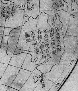
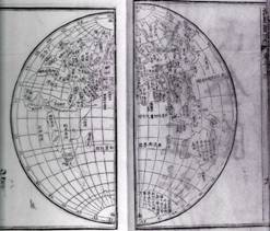
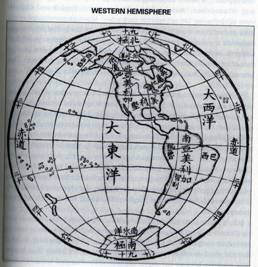
up to and into the 19th century. It is shown below as it appeared
originally:
|
|
|
|
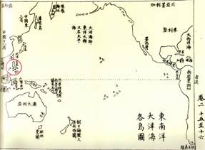
(a) Eastern Hemisphere of the world (including Australia)
|
(b) Western Hemisphere of the World (including New Zealand)
|
The description of the Hemisphere map in “Treasures of maps”
is: “Map of the world in two hemispheres, from the ‘Illustrated Geography of the World’ (
海国图志
, Haiguo Tuzhi)
compiled by Wei Yuan (魏源, 1794-1856),
printed in three editions in 1842, 1847 and 1852 in fifty, sixty and 100
volumes respectively.” The Figure above shows the four pages with the
Hemisphere maps from the 1852 Edition of “Illustrated Geography of the
World”. The Figure below shows a detail of the large island in the south of
the eastern hemisphere”
What is striking on this map is the set of characters
“Aodaliya Zhou” (奥大利亞州)
among other annotations on the southern continent. This name is very close to
the modern Chinese name for Australia which is “Aodaliya” (澳大利亚) for the large island and “Ao Zhou” (澳洲) for the continent. The full
set of information written in Chinese on the map can be roughly translated
as:
|
Australia [or Australasia];
Also called south Nova Hollandia;
Mostly desolate and;
Devoid of people;
Nowadays a colony of Britain.
|
奥大利亞州,
即南國之新荷蘭地亞,
大塊俱荒,
杳無人物,
今為英吉利藩属地
|
The document made available below was originally started to
undertake more research and to answer the questions that arose from the above map.
The map suggested an initial working
“hypothesis” which was that the map shown above also appeared in Wei Yuan’s edition
of 1842, and that it was there because a Chinese transliteration of “Australia” had become needed.
It seemed possible that the name arose when Wei Yuan needed to
construct hemisphere maps of western regions using Chinese characters when China needed to find out more about the
belligerant western foreigners and their encircling colonies. It also seemed possible that it was Wei Yuan who
may have devised the transliteration and
that the 1842 Edition map was the first Chinese map on which the modern name appeared.
In the end, very few of these apparent possibilities turned out to be the truth!
But, of course, for some initial ideas to turn out to be the whole story would have been much TOO simple!
A BRIEF SUMMARY OF THE HISTORICAL SITUATION
The year 1842 was a significant time for China in the
history of interactions between China and the “western foreigners”, meaning the nations
that had arisen in Europe and the America’s and, following their industrial revolution, had been arriving at China’s
gates for a few centuries prior to 1842. In recent times, the East India
Company had been trying to open China to its trade and establish favourable
terms of Trade. This included access to Chinese markets for the goods being produced by industrialisation,
as well as flexible access to the interior. However, they were
faced with a complex system of controls as well as little interest by Chinese for their products and longed to
break free of rules made up by Chinese. To
improve the terms of trade, the company had encouraged the unofficial and
illegal traffic in Opium along the China coast. The Company had a monopoly of
production in India and by the 1830’s the Opium trade had displaced the
legitimate trade as the most active and profitable activity. In 1839, Lin
Zexu (林則徐,
1785-1850) went to Guangzhou with the intent to stop the illegal
trade. To be brief, he failed, and as a result of the “injury” to trade
caused by his seizure and destruction of a large amount of British Property
(opium), the first Opium war occurred. It resulted in the first of the
“unequal” treaties (the treaty of Nanjing), the opening of five Treaty Ports
on the China coast and Lin Zexu being sent to Yi Li in Xinjiang on the boarder with
Russia. It also resulted in a dramatic
increase of curiosity amongst Chinese scholar-officials about the western foreigners and a strong
desire to find as much as could be found about their geography, history, religion, language
and nature.
WHO DISCOVERED THE CHINESE NAME FOR AUSTRALIA?
Lin Zexu and Wei Yuan were two significant contributors to
the development of Chinese geography of the outer world. They each wrote books outlining the countries of the
world and information about their peoples and their histories. Wei Yuan’s
book has been mentioned above and it originally developed from Lin Zexu’s
book called “An Account of the Four Continents” (四洲志, Sizhou Zhi, 1839) and a range of other material in Chinese
written by Chinese and western people. Two other scholar
officials, Liang Tingnan (梁廷枏, 1796-1861) and Xu Jiyu (徐继畬, 1795-1873)
were also to contribute books in the 1840’s and the four books together
changed China’s base of knowledge, provided maps of the world and its countries
and outlined the changed world geopolitical situation. Liang Tingnan’s book
was called "Four essays on the Maritime Countries" (海国四说, Haiguo
Sishuo, 1846) and Xu Jiyu’s book was called “A short account of the oceans
and surrounds” (瀛环志略,
Yinghuan Zhilüe, 1848). Wei Yuan claimed his book (from which the two
hemisphere maps above come from) was about “how western people perceive the
west” whereas previous Chinese books have been about “how Chinese people
perceive the west”. His changed view was shared by the three books mentioned here. Their interest eventually developed to include even the
far south of Asia with its large island continent. But Lin Zexu had little
interest in Australasia and the Pacific and Wei Yuan waited until the 1854
edition to have a comprehensive section of text on Australasia. It was therefore left to Liang Tingnan and Xu
Jiyu, who were no doubt even more concerned at the rapid growth of British
colonies, to first include additional significant information and then use the modern name for Australia in
both text and maps. Wei Yuan incorporated their findings into his final
edition of 1852. Their overall activity created the modern Chinese name (in the sense of being a name that Chinese use) for Australia.
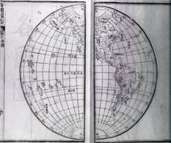
|
|
|
|
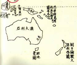
Map by Xu Jiyu of the Pacific Ocean or “Oceania” showing
Australia.
|
Detail of Australia (from Go and Sy (2000) with Chinese
name.
|
WHO DISCOVERED THE NAME FOR AUSTRALIA IN CHINESE?
But the name for Australia in Chinese (as distinct from
the Chinese name for Australia) existed before Lin Zexu went to Guangzhou to
confront the foreign drug traffickers and became interested in bringing
China’s geographical knowledge up to date. Since the beginning of the 19th
Century, it was not only traders who gathered at China’s gates hoping to be
let in. An increasing number of Protestant Missionaries arrived with the
millennial zeal of the times and its hope of a great awakening of Chinese
people to Christianity – at least the particular brand that they were
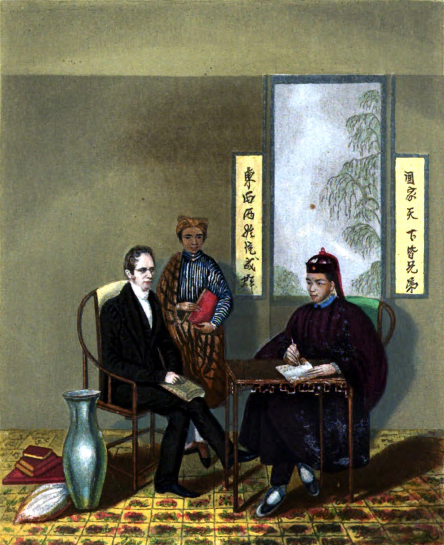
preaching. The first was a Scottish Missionary called Robert Morrison (Ma
Lixun马礼逊 ,1782-1834). He
and others worked hard to learn Chinese with the aim to distribute tracts and
Bibles in the Chinese Language. Later, American missionaries such as Elijah
Bridgman (Bi Zhiwen, 裨治文,
1801-1861), arrived with an even greater evangelical millennial zeal than
Morrison. Morrison, in the face of restrictions in Guangzhou, started the
Anglo-Chinese College in Malacca where Chinese learned English and a printing shop generated
tracts that were distributed widely in the south of China by converts.
Unfortunately, some of these early tracts inspired the pseudo-Christian
Taiping cult. The appearance of the Taiping was initially welcomed and
supported by some Missionaries as the start of the great awakening but they
reluctantly abandoned it when it was clear they were not what the Missionaries
had hoped.
Among the Missionaries were many hard working and
capable people who mastered Chinese and contributed much to the
intellectual life of the foreign community at Macao, Guangzhou and (later)
Hong Kong and the Treaty Ports. There were some unique characters as well, such as the
energetic, unpredictable but still brilliant Karl Friedrich August (Charles)
Gutzlaff (Guo Shilie 郭實獵,
1803-1851). Gutzlaff wrote many tracts and books of varying quality and
distributed them widely through southern China with the help of Chinese
evangelists in his “Chinese Union”. Gutzlaff believed China would only become
Christian through the intermediary of Chinese preachers. Other
Missionaries disliked him because of this and possibly also because he was
more successful at raising funds. They eventually turned on him, but only
after he had lost all of his money in speculative land investments in Australia.
|
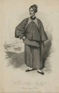
Charles Gutzlaff in the dress of a Fujian sailor by George Chinnery
|
However, Gutzlaff and others also had a secular humanist
side and they strongly supported the development and diffusion of knowledge
including history, geography, science and economics. They did this
comprehensively in locally printed Chinese language books. It is arguable
that China benefitted more from these contributions than from the religious
tracts and Bibles in bad Chinese. To be brief, one of Gutzlaff’s
contributions was a magazine that has been called by some the first Chinese
language magazine printed in China. It was called the “Chinese Magazine” or
Dongxiyang kao meiyue tongji zhuan 東西洋考每月統計傳
(more literally the ‘East-west examiner and monthly recorder’). It was
compiled by Gutzlaff using his own and others’ contributions. It was printed
first in Canton (1833-1835), and later (when Chinese banned Missionary
printing) in Singapore, (1837-1839). It contained many interesting articles
and among them, in 1834 and 1835 appeared one that outlined the major
continents and the most important countries in them. Included was the
smallest continent and a description of its single country – Australia
transliterated as Aodaliya (澳大利亚). This publication provided
Chinese with a name for Australia in Chinese as well as other geographic
information about the new world. Both were later eagerly picked up in the frantic
activity of the 1840’s described above
(especially by Liang Tingnan and Xu Jiyu) to produce the accepted modern “Chinese
name for Australia”.
The last question we tackled was who wrote the article? This occupied some time while
the document was held in draft form . The progress of the
research was followed in another document called "Afterword_to_CN4A" available below
and as a result of this research the answer that has been given is that it was
the British missionary Walter Henry Medhurst for reasons that can be found in the
final versions available below.
The positive role of the Missions in the
diffusion of knowledge was much more productive than some other activities of
missionaries. But it was not only Charles Gutzlaff and Walter Medhurst who were engaged in this
diffusion. Elijah Bridgman provided Lin Zexu with material for his book and
recommended and arranged for Lin Zexu to buy a copy of Hugh Murray’s
comprehensive “Encyclopedia of Geography” from which “An Account of the
Four Continents” was translated by Chinese translators assembled by Lin. Bridgman and Lin shared a strong dislike of and opposition to the
opium trade. Another American missionary David Abeel (Ya Bili, 雅裨理, 1804-1856) provided Xu Jiyu
with many maps and other materials and translated and transliterated for him
as well. But Liang Tingnan and Wei Yuan did not seem to seek the company of
foreigners – especially missionaries. One of Liang Tingnan’s four essays was
called “Difficulty of China accepting Protestantism” (耶稣教难入中国说). Nevertheless, by the 1860’s the
Chinese name for Australia was well established and official. Even the newly
formed Chinese Diplomatic Bureau (the Zongli Yamen, 總理衙門) was using
it.
|
|
|
|
Hemisphere maps from Chinese
translation of Wheaton’s “Elements of International Law” (Wanguo Gongfa, 萬國公法), by the Zongli Yamen (總理衙門) in 1865
|
SUMMARY OF FINDINGS
As with anything involving many players, the story was not
always simple and there are many interesting details that cannot fit into a
summary such as this. A name was also only a start; a named country also needed to be associated with
information about its people, religion, resources, harbours and
fortifications etc. How all of this resolved and was published in time for
the Gold Rushes and the other interesting details that have been only quickly
brushed over here are to be found in the main document and some
ancillary documents available below. The main document is called “The Chinese
name for Australia” and is available to download as a PDF file. To support
this document there are three others. One is the discussion of what was done
to resolve remaining questions (mainly to locate source material); a
second is a draft translation of the list of countries in the Chinese
Magazine of 1834/35 and the
third provides access to the full text of an English language petition by
Chinese Australians in 1879. It was too long to include in full - even as a footnote.
So, to complete this summary, I will quote from the
conclusions of the main document and then provide details of how to download the documents - if you are still interested:
"It seems that the modern name for Australia in Chinese appeared in the mid-1830’s among articles provided by Chinese literate Protestant missionaries
that aimed to diffuse western geographical knowledge for the benefit of Chinese. In particular, two articles in Gutzlaff’s DXYK in 1833 and 1834
contain the present name for Australia and these articles were to be later picked up by influential Chinese. We have provided evidence that the
author of the articles was the British missionary Walter Henry Medhurst.
From the material gathered in this document we can conclude that Chinese and western use of the names “Australasia” and “Australia” on maps and in
documents both became established at much the same time as forward thinking Chinese intellectuals, of whom the first was Lin Zexu, strove to learn
about the west to “understand how western people perceive the west”. In this they were provided with information in Chinese language by the secular
efforts of western Protestant missionaries among whom the most prominent in the diffusion of useful knowledge was Karl Friedreich Augustus Gutzlaff.
Just as New Holland had been first suggested by Jesuit missionaries, the modern name for Australia in Chinese arose from a similar contribution by
early Protestant missionaries. Chinese acceptance and use of this name occurred as Wei Yuan, Liang Tingnan and Xu Jiyu followed Lin Zexu to
assemble information and maps of the world during the 1840’s. It is very likely that Xu Jiyu in “A short account of the oceans and their surrounds”
in 1848 first used the modern name for Australia in Chinese on a map. Xu Jiyu’s choices of names were influenced by Liang Tingnan who analysed the
DXYK articles and added further information about Australia, as well as using the modern name. So it seems that Liang Tingnan can claim to be the
first Chinese to pick up the suggestion from the DXYK and accept it on behalf of Chinese people. The most comprehensive compilation of Chinese maps,
textural information and transliterations of western names as they developed over the 1840’s was certainly the 3rd Edition of Wei Yuan’s book
published in 1852. By then, Aodaliya (澳大利亚 or sometimes 奥大利亚) had become the accepted Chinese name for “Australia”.
The strategic efforts of Lin, Wei, Liang and Xu were too late and too little to help China defend itself as the British navy and army
forcibly opened China to the world and extracted reparations for China’s “injury” to the Opium Trade. But the intense interest these events
created in China about how much the adjacent seas had changed since the last time Chinese fleets had sailed them did not go away. While further
“Opium Wars” rumbled on, discovery of gold in the US, Canada and Australia and other metals in Malaysia led to a new era of Chinese history as
Chinese “Coolie” (苦力 or Kuli, “bitter strength”) labourers left China to make fortunes (usually not their own) in foreign mines.
Those who went to Australia, because of the efforts of Lin Zexu, Wei Yuan, Liang Tingnan, Xu Jiyu and the Protestant Missionaries who helped them,
had maps of where they were going, some general knowledge of what would be there and knew what to call their destination in English and Chinese."
ACCESS TO THE DOCUMENTS
The topics above are the subjects of the following four (4) documents
(to download, click and save, or (a little safer) right click and use “Save Target
As”):
(1) The Main Document (the final version of the full “story”):
The Chinese name
for Australia (PDF File 6.0 MB)
This is the penultimate document or final from me without a plan for publication. It has become a large
document with extensive endnotes containing material that
would have disturbed the "story" but (I believe) represent value to interested readers. You are welcome to download and read it.
Interested people are also still welcome to offer comments and feedback as well as
corrections, additions, deletions, suggestions etc. which can be profitably added. Contact me at:
dlbjupp@ozemail.com.au
(2) The Afterword that discusses source texts used to resolve the question of who "discovered the name for Australia in Chinese?":
Source texts and research used to complete
'the Chinese name for Australia' (PDF 936 KB)
The Main document remained as a Draft for a long time while the question of who wrote
the articles in CN4A with the modern name for Australia in 1834 and 1835 was researched. A conclusion has, since then, been reached.
The background working document has been updated but also retains traces of the early discussions and pathways traversed as they
still provide additional support and evidence for how the conclusion was reached.
(3) A Draft Translation of the List of the main countries by
continent in DXYK (1835) in PDF format (65 KB).
In addition, a translation of the section from
Gutzlaff’s “Chinese Magazine” that includes the name for Australia and some information about it is also available as a third document. If you can
help identify remaining errors made in identifying the countries it would be
very helpful! The transliterations of a number of the western names are rarely used now
by Chinese so it is not easy. The “Chinese” language in the original document was also written by an
English missionary (Walter Medhurst) and so sometimes it is really neither "Chinese" nor "English". Its interpretation can then be like a “cryptic
crossword”.
(4) The full text for the Petition
Finally, the Petition “The Chinese Question In Australia
1878-9 By L. Kong Meng, Cheok Hong Cheong & Louis Ah Mouy” (Melbourne,
F.F. Bailliere 1879) is no longer included in the main document (only the first
4 paragraphs are now included in the Endnote). The full document provides
a direct reference to a web link as well as this locally stored PDF file to access. The reference
is from an ANU Thesis (Welch, 2003) that includes an Appendix of 14
Australian petitions by Chinese Australians written during the Nineteenth Century. The Petition referred to in CN4A
can be accessed as Appendix 1 in the List of
14 Appendices from Welch (2003) (PDF 2.7 MB). (If it opens at other than
Appendix 1 please navigate to Appendix 1).
A Final Word
2024 is the Dragon year!
Even more successful researching to you all in the JiaChen Year of the Dragon (甲辰)!
The Rat year of 2020 was the 庚子
(gengzi) year. This was the cycle year of the start of the Opium Wars (1840) as well as other disasters for China.
The Ox Year of 2021 was the 辛丑 (Xinchou) year. The second year of the Opium Wars (1841) had this name
and we had the COVID pandemic! Only China did not contribute to the incubation of new varieties.
In the Tiger 壬寅 (Renyin) year of 1842 the British forced the first unequal treaty at Nanjing while in Afghanistan their
retreating forces were massacred. The punitive response was harsh but they left Afghanistan - perhaps to focus on China. Our world also saw attacks and retreats and massacres
with the powers occupied but wishing to focus on China! Then China opened to Covid. In 3 weeks 600 M people were infected with peaks over by the time the Rabbit year of Guimao arrived.
Are Chinese all now Yang Kang (杨康)? Time will tell.
In the former Rabbit 癸卯 Guimao year of 1843, the 'wolf warrior' approach of Lin Zexu gave way to more accomodation,
Treaty Ports opened, the (still unofficial) opium trade flourished and Xu Jiyu was posted to
Xiamen in Fujian. There is lots more in the document if you wish to see. The foreigners established forts, demanded accomodations and built up their power.
In 1844, the year of the Dragon, the general conditions were similar to 1843 but the scholars of our story of Australia's Chinese name were very busy. The material China needed to be able to learn about the foreigners was being assembled.
龙年吉祥!!
甲辰来到了,祝福如意!
The Final and penultimate web version of the document still (!) awaits a formal publication as it has for some time now. Suggestions and/or help for
E-Book, translations or other forms of publication are welcome and it may get an update and edit soon. It is still here much the same for you to read if and when you wish.
☺.
David Jupp
Feb 10 (甲辰), 2024.
|