|
Introduction to Hanzhong Museum
David L B Jupp September 2006
1 Background
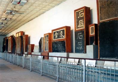
The Hanzhong Museum manages a significant collection of China’s cultural relics including artefacts and literature and has a deep association with the Shu Roads that have crossed the Qinling mountains since ancient times. These include a number of famous roads, including the Baoxie (or Baoye) Road between the Wei River valley and the Hanzhong basin. Information on the history of the Baoxie Road and other plank roads is presented in a special display room at the Museum. The display also includes many ancient treasures of high literary and archaeological value such as the Thirteen Stone Gate treasures (ancient calligraphy originally carved on cliffs) and ancient scrolls.
This document briefly introduces the geographical setting of Hanzhong and its Museum and then presents two excerpts from a book (in Chinese) called “Hanzhong Museum” (Feng, 2003). It was written by Director Feng Suiping and is available at (and from) the Hanzhong City Museum. The first excerpt provides a general setting for the Museum and the second provides an introduction to the Baoxie Plank Road Exhibition Hall and its exhibits. It will be clear from these brief excerpts that the Museum is the location of a wide and unique collection of China’s archaeological, cultural and literary history, the history of the Shu Roads and the ancient history of “Han” culture.
2 GeographY
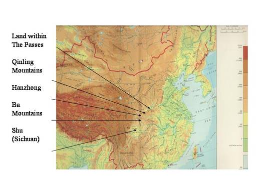
In the west of China lie three protected basins surrounded by mountains and other natural barriers. The most northerly is the catchment of the Wei River and its tributaries in Shaanxi. It is known as the Guanzhong, or the “the Land within the Passes”, and has been the location of many events in ancient Chinese history and Chinese civilisation. It was the Guanzhong from whence the Zhou, Qin, Han, Sui and Tang as well as many originally foreign northern Dynasties grew, emerged and went on to conquer and govern an ever expanding area of China. Chang’an (present day Xi’an) is the place which has been the centre of government for China for the longest period of its history. The Guanzhong takes its name from the existence of five major (and other minor) passes through the mountain barriers that form the natural boundary for the region and natural sites for fortification. The Guanzhong has productive farming land and rich natural resources – but not to the extent that is found in the north China Plain and the Yangse River plain. The valley sheep have always been fatter.
Although the Guanzhong is the best known, there are two other “lands within the passes” to the south. To the far south, across the Qinling and Ba Mountain ranges lies the Sichuan basin. Although not as widely known as the Guanzhong, the Sichuan plain has been the site of ancient civilisations which grew in parallel with those of the north and east. Sichuan has always been a rich and fertile area and has also often been able to avoid the turmoil of the east of China through its natural protection by high mountains. But not always, as it was the natural resources of Sichuan that brought Qin across the Qinling, building the first recorded mountain roads to conquer and develop its agriculture and natural resources. The ancient name for Sichuan was “Shu” or silkworm and the silk of Sichuan was traded across the northern Silk Road well before its “discovery” by Zhang Qian in the western Han period.
Finally, between these two areas, south of the high Qinling mountains and north of the Ba mountains lies the Hanzhong basin. The Hanzhong basin was known in ancient times as “Yu Pen” or the Jade Basin for its rich natural resources and these, together with its position has made it the linking region for the traffic that grew as people found ways to move across the mountains between the Guanzhong and Shu and ways to move along the Han river to link Shu, Guanzhong and the lower Yangse river area. The roads they built between north and south were called the “Shu roads”.
The most ancient linked the Wei Valley with Sichuan along the Chencang road between Baoji and Guangyuan, the second was the Jinniu (Golden Ox) road from the border between the Shaanxi border and Chengdu which were made into a network by the linking Cloud Link Road from Fengzhou to Liuba which joined the famous Baoxie Plank Road linking Xi’an and Baocheng. In addition, link roads from Xi’an to the Hanzhong valley were also used. They were called the Ziwu road and the Tangluo Road. To the south, the network extended as two other linking roads joined the Hanzhong basin with the south. They were called the Micang and the Yangba Roads. In the Han times, the Baoxie Road was especially famous. It will be described in the second of the excerpts. Some idea of the spreading network can be obtained by the following Figure presented with Google Earth as backdrop.
But the traffic did not only connect settlements and transport people goods and armies between north and south. The mountains also divide the environment and climate of China into north and south. They separate the drier, predominantly wheat growing areas from the wetter, predominantly rice growing areas by stopping the northward movement of the Asian monsoon. The climate at Hanzhong reflects a balance of those of the north and south as well a balance of the cultures of the north and south. The environment surrounding the Shu roads provides paths of communication between north and south at all levels and of all kinds. This document is not the place to go into the general history of the Shu Roads. The web site developed for a cooperative project between Australia and China has a general introduction to this history (Jupp, 2009) and also provides access to a comprehensive Thesis on the Shu Roads written by Herold J. Wiens (Wiens, 1949).
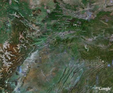
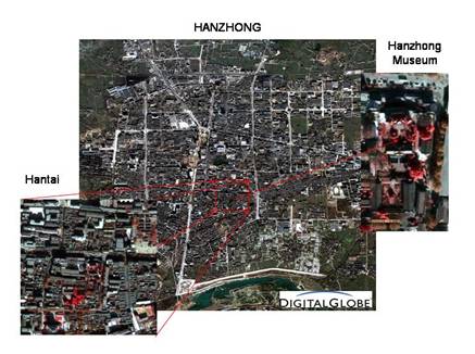
The position of the Hanzhong Basin (Han river valley) in between the two major mountain and climate gradient systems formed by the Qinling and Ba ranges is well illustrated using the following image from Google Earth:
The city of Hanzhong lies below the first “n” of Hanzhong in the above illustration. Known as Nanzheng in former times it has had a long and (to many) surprising history. The first translation to follow will outline some of the surprises. The Hanzhong Museum is in an area called Hantai which was the original centre of ancient Nanzheng and is built on the site of the ancient palace of the first Han Emperor Han Gaozu. This document is also not the place to pursue this history but an outline of the general history of the Shu Roads from the vantage point of Hanzhong at their centre can be downloaded HERE.
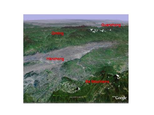
The Museum is located in the southern section of the city as shown in the following remotely sensed image of the city. It is a beautiful site and houses many cultural treasures to see and enjoy.
3 An Introduction to the Museum
The following introduction to Hanzhong and its Museum is a translation of the Preface from a book written by Director Feng called “Hanzhong Museum”, (Feng Suiping, Three Qin Press, 2003). The Chinese Text is included as Appendix 2 in this document.
‘Hanzhong, in the midst of the Qin and Ba mountains, is quite unassuming, and not even easy to locate on most maps, and yet it has great claims to fame. Not only does the region have unique natural resources, giving it the reputation far and wide as “The little South China of the northwest” or “Shaanxi's land of plenty”, but it has also been a stage on which for some thousands of years the history of the Chinese people has been played out. Furthermore, it has been a background for famous novels and events from ancient times of deep and lasting cultural significance.
Through its association with the events behind the expressions “Openly repair the plank road, secretly approach Chencang”, Xiao He pursuing Han Xin in the moonlight [1], peace created in troubled times by the “Five Pecks of Rice” Daoist rebellion [2], “Spare no effort to do one’s duty without stopping unless [until] one dies” and “ War horses fight bravely at the Great San Pass “ [3] etc, Hanzhong’s fame is well known, and often re-told in the annals of its colourful written history.
But Hanzhong's long history does not only consist in these events. Among the great historical cities of China, Hanzhong possesses an amazing wealth of history and culture, including the site of the Neolithic Lijiacun Culture, Shang & Yin dynasty Bronze ware and other relics at Baoshan [4], the Han period Temple of Zhang Liang, the tombs of Zhang Qian (discoverer of the Silk Road), Li Gu (incorruptible later Han statesman), Cai Lun (inventor of paper in the later Han) and the Three Kingdoms tomb and temple of Zhuge Liang (the Martial Lord of Shu Han) [5] etc, to name but a few. In the midst of these relics of history and culture, in the heart of Hanzhong city lie the “three relics of the early Han”. These are the ancient Hantai, the Alter of Conferring Titles and the Pool for Watering Horses. [6] These create a heavy responsibility as with all significant historical sites for their care, especially the ancient Hantai, which is a famous drawcard for the historical culture of the city, and provides a link between ancient and modern history.
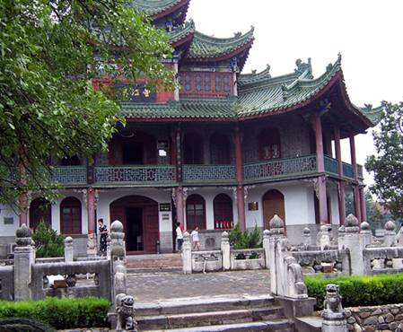
The Hanzhong museum was built in 1959 at the site of the Ancient Hantai and has developed over 45 years through the untiring efforts of its staff into a combined Museum of historical records and of historical relics, becoming one of the “Ten Great Shaanxi Museums”. Nowadays, when you experience it for yourself, it is like walking through a delightful garden and experiencing its fragrances with each step. You can visit the Wangjiang Building and the Guiyin Hall [7] and view the inscriptions “Gun Xue”, “Stone Gate”, “Jade Basin” and “Stone Tiger” [8] etc. These have all become “trademark characters” for Hanzhong people, and are widely used by all trades and professions.’
(End of Translation).
NOTE: In the above and the following translations, the numbers in square brackets refer to a set of brief end notes which expand on the statements in the Preface. The notes also provide some additional background to the discussion of the Baoxie Plank Road and its Exhibition Hall which will come next. The Notes are included as Appendix 1 of the current document.
4 The Baoxie Ancient Plank Road Exhibition Hall
The following is a translation of a section with the title above from the book written by Feng Suiping called “Hanzhong Museum”, (Feng Suiping, Three Qin Press, 2003, Page 25). The Chinese Text is included as Appendix 3 in this document.
‘In the development of human civilisation, later generations sometimes cannot but admire the outstanding intelligence and wisdom of their ancestors. Although technologically primitive, their feats can amaze experts and later generations often find it hard to fully appreciate the significance of the historical message. The Baoxie Plank road is an example of such a situation.
To the north of Hanzhong lies the protective screen of the Qinling mountains and to the south the dangerous and difficult Ba mountains, together making the Hanzhong Basin a closed geographic area. The ancients increasingly expanded their territory, and after making explorations through the Qin and Ba mountains, opened up many paths for communication and traffic. The different tracks across the Qinling included the Ziwu road, the Tangluo road, the Baoxie road and the Old Road (the Chencang road). Passing through the Ba mountains were the Jinniu (or “Golden Ox”) road, the Micang (or “Rice Granary”) road and the Yangba (or “Lychee”) minor road. These seven roads are generally known as the Shu roads.
As the name suggests, the Baoxie road followed the paths of the Bao Shui (today's Bao River) and Xie Shui (today's Shitou or “Stony” River). The ancients often passed through these areas to make surveys before finally deciding the best way to cross the steep backbone of the Qinling to smoother areas. The way selected was in Taibai county over the Wulipo (a saddle dividing the Bao and Xie catchments) to link the north with the south. More and more people used it and gradually formed the road. The Baoxie Road starts in the north in Meixian county at the Xie Valley entrance, and comes out in the south at the entrance to the Bao Valley to the North of Hanzhong. In all, its length is 235 kilometres. It provided the main artery for traffic through the Qinling and became the oldest, longest serving, and largest of the Shu roads as well as the one with the greatest reputation. Successive generations continued to build and repair it reflecting the original enterprise and the Plank road spirit. Its presence has created a prosperous society and a wealth of historical culture for the people of Hanzhong.
The Baoxie Ancient Plank Road Exhibition Hall was completed by the professional staff of the Hanzhong city Museum following thorough research and field studies. With the passage of time, this research has reached increasingly greater depths. For that reason the Exhibition Hall has recently been reconstructed on the base of the original material. Let us take a visit together to the Exhibition Hall.
Room 1: “With endless twists and turns, the Old Road has stood there long” -- The origins of the Baoxie Ancient Road
There were originally no roads, just a simple track used by many people. The Baoxie road came about through the desire of ape-man and other ancients to know the outside world. In doing so they followed the Bao and Xie rivers many times and gradually found the way. You can trace back this kind of history through the Neolithic Liangshan culture and Chengyang bronzes. In regard to this particular route, historical documents have emerged, as well as legendary tales. These stories tell of the Three Primordial Sovereigns (Fuxi, Shennong and Huangdi) emerging from the valley mouths, of the Shu alliance in Wu Wang’s (Zhou founder) striking down of Zhou (last Shang emperor), signal beacons alerting the feudal lords, the Qin rule being established at Nanzheng, Wu Ding opening the (Jinniu or Golden Ox) road to Shu and fire destroying the Plank Roads etc. From the modern displays in the Exhibition Hall you can deepen your knowledge of ancient history as well as appreciating the development of the Baoxie road through the amazing way the plank roads arose.
Room 2: “Trestle bridges suspended in the air, flying along the cliff” -- The construction of the Baoxie Plank road
In the mid to late stages of the Warring States period, when iron was in general use, the Plank sections appeared along the Baoxie road: “The 1000 li Plank Road links them all, the Baoxie road controls the entry”. In the time of the Former Han emperor Wudi, 10,000 labourers were engaged in large scale construction. After that time, successive generations maintained it. After the Northern Wei dynasty, the plank roads were gradually replaced by cliff roads (cut from the rock) and in the Republican period (1940's) the Baoji to Hanzhong highway brought about further change. Nevertheless, the Baoxie Plank Road had been a vast engineering undertaking, involving difficult construction, great skill and one of the great miracles in the history of ancient transportation.
Plank roads, also known as Trestle roads and Balconey roads, are a road design created by ancient workers to suit mountainous terrain. Generally speaking, a Plank Road is constructed using holes in a cliff to support cross members, post hole and upright posts as well as planks etc. First holes were punched into the steep cliffs into which were placed the posts; then the trestles were built across them, to become a roadway that hung suspended in the air. They looked like great dragons winding through the valleys. Archaeologists, on the basis of field studies, have established the different forms of the Plank Roads using reconstructions.
Based on their architecture, the Plank roads can be divided into the Standard Form, the Hillside Shelf Form, the “1000 beams without pillars” (Qianliangwuzhu) Form, the Accumulated Rocks Form, the Multilayered Bridge Form, the Recessed (notched) Form etc. The Standard Form comprises square holes chiselled into the side of a cliff supporting horizontal planks and strengthened by holes cut into the rock of the river bank for uprights put into place and afterwards the planks and beams locked to create the road. Yangwang Cliff in Liuba County and northwest of the Shimen tunnel have this type of Plank road. The Hillside Form and the Standard Form are not the same, as in the Hillside form the lower beam holes are dug into the mountain slope so that it is just like putting up a wooden shelf, hence its name. The “1000 beams without pillars” Form is built on the sides of steep cliffs where the water is deep, with the stilts holding the road needing to be very high and where it is not possible to place uprights, the number of holes is increased to improve the load capacity.
In regard to the Accumulated Rocks Form, the recorded “Stone Gate Ode” says: “Built accumulated rocks are the foundation of the ages”. This form uses rock accumulations to create a road. Along the Plank Road, there were often small spurs of rock where ancient people chiseled the rocks until they became a trough and formed the Recessed or notched Form. But the most complex Form of Plank Road was the Multilayered Bridge Form which was spread along steep cliffs developing a single crossbeam layer into multilayers using vertical beams to link the upper and lower sections to create this form of road. Mingyue Gorge, in Chaotian District of Guangyuan City in Sichuan has this form of Plank Road, and now it has become part of one of the top tourist areas among National famous tourist areas based around the Jiange Shu road scenic area. Generally speaking, Plank roads in the lower reaches of rivers need to be 5-8 metres above the surface whereas in the upper reaches they only need to be approximately 3-4 metres. Furthermore, not all sections of a road need to be Plank Roads. These forms of Plank roads are those most commonly used by the ancient people, and to sum up, we can reflect on the wisdom and talents of our forebears, continually opening up new lands with great spirit and enterprise as is shown by the (archaeological) relics of their efforts.
The Baoxie Plank Road also includes an early engineering feat of road building in mountainous areas which is one of the most highly deserving of the attention of later generations. This is the Stone Gate tunnel. Faced with the precipitous Chicken Head Pass, the ancient people overcame all obstacles, when in the Eastern Han Yongping period, the emperor Han Ming made an imperial decree for the repair of the Baoxie Plank Road, and the opening of the Stone Gate tunnel. The “Stone Gate Ode” records: “As to the Yongping, in only four years, it opened Xie and cut through the Stone Gate”.
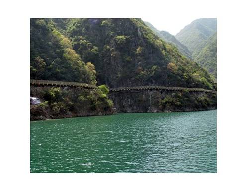
According to field observations made after formation of the PRC in 1949 (and before it was flooded in 1979), Stone Gate is oriented close to north-south and is parallel to the direction of the Bao river valley. It had the same direction and base level as the main Plank Road which also ran north-south. This explains how the north and south were linked in a way that was flat and easy to travel. Because the two sides of the mountain are not symmetrical, the lengths of the east and west walls of the tunnel are not the same. The east wall is 16.5 metres long and the west wall is 15 metres. The south entrance is 3.45 metres high and 4.2 metres wide and the north entrance is 3.75 metres high and 4.1 metres wide. According to the requirements of the Han period, the interior of the stone Gate tunnel needed to allow two vehicles to travel abreast or pass when going in the opposite direction. Having Stone Gate open to traffic greatly facilitated the flow of traffic and brought about a great change in the Baoxie Road and Qipan Mountain sections and made travel and traffic flow very convenient. The Northern Wei inscription "Stone Gate Engraving” said: "A vaulted passage, with rattling carriages, a smooth stone road, where four-horse teams can pass, unmatched in 1000 years, so many new vehicles have appeared”. This was displayed on the occasion of the grand opening of the Stone Gate to traffic from the Baoxie Road.
Stone Gate is a famous example of mountain tunnel engineering. But how could it have been cut? According to archaeological investigations made at the time when the Stone Gate entrance was exposed, the rock material is unusually hard with an undulating surface, but the surface is very smooth without traces of the marks of the workers tools. The Qing period writer Jia Hanfu in "Repair the Plank Road Song” wrote: "Using piled wood and fire will split the stone, so hammer and chisel can peal it away”, so it seems an explanation for the situation at the Stone Gate is that in the Eastern Han period they used the methods of baking by fire and freezing with water to cut the stone. However, this hypothesis needs to be carefully considered and has some shortcomings.
Inside the tunnel were 42 historical stone inscriptions. If the hypothesis were correct, the surfaces of the inscriptions should show the influence of the baking fire and freezing water. Given the long time involved, the rock surface should show some deterioration, and the surface of the stone inscriptions should be blurred and illegible or show signs of peeling off. Furthermore, since at least the Song period there have been hundreds of years of rubbing (to make copies of the inscriptions) and other wear and tear, so it is hard to imagine that today the surface of the Stone Inscriptions would not be in poor condition.
When you walk into the Exhibition Hall and look at or touch the engravings, you will discover the "Stone Gate Ode”, the "Stone Gate Engraving” and other inscriptions, covered with the marks of rubbings and ink from a long period, with the stone surface complete and intact, and the characters on them quite clear so that many scholars can admire them. Therefore, to say that they used the method of baking by fire and freezing by water to cut Stone Gate is not satisfactory. From the modern viewpoint, they did not have modern blasting technology, nor did they use modern drilling tools to tunnel, so how was the Stone Gate tunnel opened? This currently remains an ancient riddle.
Room 3: "Shu roads and Qin passes, pass through the natural barriers” -- Baoxie Plank Road traffic
The original Room has now been subdivided into sections on traffic engineering, postal stations and the poetry associated with the ancient carriageway. These reinforce the idea that although the Baoxie road was a traffic route that for many years provided the main artery for traffic across the Qinling it was also a cultural pathway. Here, you can gain an appreciation of the different engineering structures of the past, of the claims of Baocheng to be the first among the postal stations of the Tang period, as well as enjoy the wonderful sight of the poetry and songs, stone stele and Plank Road scroll paintings.....
Opening China's classic documents, you can often come across passages relevant to the records of the Baoxie Plank road.
"Poor gives way to Wealthy, Junior to Senior, Light to Heavy, Leaving to Arriving”
This is a Southern Song stone inscription entitled "Rules for (road) etiquette and is the earliest specimen of an example of "Rules of the Road" in China. It can now be seen at the Lingyan Temple at Lüeyang.
"The harsh Qin built this post station, Water is plentiful in the station well, Countless canes of bamboo are growing, Along with many pear trees. Four years and three and one half months, A time of new (bamboo) shoots and late flowers, Longing to go again over the mountains in the East, I idle time and compose poetry."
This poem by the Tang poet Yuan Zhen ("Baocheng Post") enables people to appreciate the beautiful scenery of former Baocheng as "The greatest post station".
In fact, even if you only browse for a while, you will discover that many men of letters have travelled the Baoxie Road, travelling between Qin and Ba, coming and going between the Wei River (Guanzhong) and Sichuan basins. They include the Qing period Shenyun group poet Wang Yuyang, who in the Kanxi period travelled the Plank Roads three times, or the poet of the Xingling group, Zhang Wentao, who in the Qianlong Jiaqing period experienced the roads on six occasions. These two great Qing period personages of competing schools in history of poems and songs went along the Lianyun road at different times creating their poems and songs. This was a unique expression of Plank Road culture. The famous Ming period geographer Wang Shixing's "Shu sketches" and "Shu Diary", Wang Yuyang's "Shu postal road Diary" and "Qin Shu postal road diary", Zhang Bangshen's "Records of travelling the Cloud bridge (Lianyun) road", Chen Yixi's "Record of service in Yizhou", Tao Shu’s "Diary of an envoy to Shu", Zhang Suhan’s "A brief account of Shu engineering", Wang Zhiyi’s "Wandering in south Han", Yu Pingbo's father Yu Biyun's "By carriage to Shu poem", the famous Japanese Sinologist Zhu Tian Jing Jing's "Diary of cloudy Plank Roads and rainy gorges" (in Japanese) etc, all record the glorious history of the Shu roads and confirm all of the ancient stories.
The ancient Baoxie Plank road brings us the history of the past, carries it into the present and will take it on into the future. At the same time as we gasp in admiration of the ancestors intelligence we cannot but have great excitement at the rapid development of the present time. As with the Baoxie Road and its ancient Plank Roads, today's scientists and craftsmen with great effort and hard work bring about further information and display, to create source material for the benefit of society and especially for the education and development of national pride among today's young people.’
(End of Translation)
5 Conclusion
Hanzhong is the centre of a long tradition of Chinese history, culture and literature as well as the central focus of the ancient roads that linked the Wei River valley in the Guanzhong with the Sichuan Plain to the south of the Qinling and Ba mountains. The Museum and its staff have played a key role in developing material to educate Chinese and foreign alike in the geography, history and environment that contains the material Shu Roads.
This document has been prepared as part of a cooperative Project called "Australia-China Cooperation to Enhance the Knowledge and Impacts of Historical Culture through 3S Technologies in the Hanzhong Area of Western China". The Project ran between 2006 and 2009 and has a web site outlining its outcomes and collecting its outputs. Among the outcomes was an International Symposium that was held in Hanzhong in May 2007 to introduce the ideas and tools of modern Geographic Information Science into the framework of the Museum and others who are conserving the history and culture of the Shu Roads. The proceedings of this Symposium are referenced on the web site.
The Hanzhong Museum is, in westren terms, a Museum, a Library and an Art Gallery. It has well developed aspects and extensive collections relating to of all of these with the common thread that they all involve significant aspects of China’s long history and with particular attention to the Shu Roads. Its activities involve preservation, conservation, field investigations, archaeology and research into all aspects of the collections including areas such as the history of calligraphy and the poetry of many periods. These activities involve preserving ancient stone inscriptions and scrolls but equally need urgently to establish how to preserve and manage the large (over 400 plates) collection of photographs from the last 100 or more years, some of which are the only print or copy of now non-existent sites or relics. With their hard work and the collaboration of the many groups who are interested in this history both in China and overseas, it can be confidently predicted that the Shu Roads will become well known throughout the world.
6 Acknowledgements
Hanzhong Museum Director Feng Suiping has provided the material presented in translation. Mr Li Lingtao helped with the translations and the history. His knowledge of history and preparedness to advise are both remarkable. Photographs were taken during field work carried out for the Cooperation project unless otherwise indicated. The first map was scanned from Herrmann (1966) "An historical atlas of China".
7 References
8 Appendix 1: Notes for the translation of the Preface
[1] Events at the beginning of the Han
When the Qin dynasty fell in 207 BCE, the general Liu Bang was made king of Shu, Ba and Han and went to Nanzheng with the remnants of his army. Sima Qian's "Records of the Grand Historian" (Reference 3) states that Liu Bang went to Nanzheng by the "Li Pass" but there were possibly plank roads along the way they took as it records that they were destroyed to stop pursuers. Later, Liu Bang's adviser (later Prime Minister) Zhang Liang persuaded Liu Bang to burn the Plank Road to convince the Grand Hegemon, Xiang Yu, of his intentions not to come back from Han to try and conquer China. Liu Bang's then close advisor, Xiao He, was very impressed with a man called Han Xin. When Han Xin (along with many others) deserted one night, Xiao He pursued him and convinced him to return. He also convinced Liu Bang to take him back and make him Major General in a ceremony that "conferred the title" at the Han Alter near the Hantai. The Hantai was Liu Bang's palace in Nanzheng. Nanzheng's location was in the Hantai district of present Hanzhong - basically at the Hanzhong Museum. Han Xin convinced Liu Bang that the three kingdoms of the Qin (the three Qin, basically the valley of the Wei river in Shaanxi) would crumble quickly if he invaded and that the people would welcome Liu Bang. He was right. To undertake this movement out of Han, he recommended that the Plank Road be openly repaired to take away the attention of the Qin kings and Xiang Yu. In the meantime, the army moved secretly along the Old Road to Chencang (today’s Baoji) which they then took and proceeded to establish the king of Han as the controller of the "Land within the Passes" or the Guanzhong - present day wei river valley in Shaanxi. In doing so they also created the famous expression (chengyu) in Chinese that means "to do one thing openly to hide another that is done by stealth". Liu Bang went on to become the first Han emperor, Han Gaozu in 206 BCE.
[2] The rule of Zhang Lu at Hanzhong
The "Five Pecks of Rice" Daoist movement was started in Sichuan by Zhang Daoling. It arose at a time when Daoism and Confucianists both took on the forms of organised religion similar to the structured systems of Buddhism and Christianity in the west. This movement was not unlike the Taiping in that it aimed to free the peasants from oppression and from the corruption of the aristocracy and landlords. The fee to join was "five pecks of rice". Zhang Daoling's grandson, Zhang Lu, led a rebellion against the Later Han and formed his own "Zhang Han" state based at Hanzhong (which he renamed Han’ning, 漢寧, 汉宁). It lasted for 30 years before Zhang Lu was defeated by Cao Cao, founder of the Wei state, in 215 CE. But he enjoyed great respect even after that time and supported Wei as the successor of the Han. After Zhang Lu had vacated Hanzhong he was replaced by Liu Bei, the Shu Han king of the Three Kingdoms period. The Shu Han Martial Lord, Zhuge Liang, used Hanzhong and the plank roads for his Northern Expeditions against the Wei state. But in the end, Wei defeated Shu Han and later a new family, the Sima family, succeeded (displaced) the sons of Cao Cao to form the Jin Dynasty in 265 CE.
[3] Famous sayings from historical and cultural literature
3.1 "鞠躬尽瘁,死而后己" or "Jūgōngjìncuì, sǐ'érhòujǐ" ("spare no effort to do your duty, do not stop unless you die") first appeared in Zhuge Liang’s 2nd memorial to dispatching troops for the Northern Expeditions (《后出师表》) sent from Hanzhong to the Second Shu Han Emperor. It can be found in the "Romance of the Three Kingdoms" (Reference 4) in Chapter 97. Moss Roberts translates it as "I shall toil to the last ounce of my strength, until my end". These words have also been used in modern times as "Chengyu" and in particular used in regard to the attitude of Zhou Enlai during the Cultural Revolution.
3.2 "铁马秋风大散关" or "Tiema qiufeng da Sanguan" is a line from a poem (Epistle of Anger, 书愤) by the Song period poet Lu You written in 1186 CE. He was stationed at Nanzheng as part of the forward defence against the Jin invaders who had defeated the Northern Song and taken the heartland of China north of the Qinling (including the Great Wall) with its boundary at the great San Pass. Lu You must have patrolled this border. He was fired with patriotism and felt that his enthusiasm was wasted by the timidity of the Song Court and its generals and their refusal to launch a "northern expedition" against the Jin. Hanzhong and the Qinling roads were the front line in the defence of China from the barbarians in the north. The San Pass was one of the five passes of the Guanzhong. It is in the Qinling mountains just south of the present day Baoji. Han Xin and the Han troops of Liu Bang are said to have hidden in the San Pass (a narrow valley rather than a single place) as they secretly crept up on the garrison at Chencang (present day Baoji).
[4] Early Relics in the Hanzhong Basin
Remains of Neolithic settlements in the vicinity of Hanzhong show that people were settled in the area for at least 7000 years. The pottery and artefacts show a linking culture between the southern people, the Longshan in the east and the Yangshao cultures prevalent in the Wei river valley. There seems to be evidence of interchange. The Shang dynasty relics at Baoshan show that the Han river valley was part of the Shang State 3000 years ago and there is archaeological evidence of advanced irrigation and cropping as well as later Zhou period bronzes.
[5] Tombs and Temples near Hanzhong
5.1 Zhang Liang was an advisor of Liu Bang and later became Prime Minister to Gaozu. His advice was very sound. He was also a follower of Laozi (the founder of Taoism) and spent much of his later life in self cultivation including what people now called Qigong, fasting and meditation. After he died in 185 BCE he became a Taoist immortal and his temple near Liuba about half way between Baoji and Hanzhong is still a place of pilgrimage. Nearby is Zibaishan (Purple Cedar) mountain.
5.2 Zhang Qian was a native of Hanzhong and a famous traveller of the former Han period. He is said to have "discovered" the Silk Road to the west. His travels are recorded in detail in the "Records of the Grand Historian" where it is said that he served as a palace attendant during the Jianyuan era (140-135 BCE). He was a diplomat and explorer of both the western regions and the south of China. His tomb is to the east of Hanzhong and has an extensive display of his travels and undertakes study into Zhang Qian.
5.3 Li Gu was a famous statesman of the Eastern Han when the court was in decline. He stood up to the corrupt power brokers and lost his life in 147 CE. But his stand is remembered by history
5.4 Cai Lun was a court official in the later Han who is credited with the invention of paper. He announced the discovery to the Emperor in 105 CE and was promoted. However, he was involved in a court intrigue and took his own life in 121 CE. Yangxian county near Hanzhong was the site of his ancestral temple and now his tomb.
5.5 Zhuge Liang (also known as Kongming, the Martial Lord, and Sleeping Dragon) was the Prime Minister of the Shu Han state during the Three Kingdoms period. He is very popular from his role in the famous novel "The romance of the Three Kindoms". He spent considerable time trying to establish the line of Liu Bei as the successor of the eastern Han dynasty and believed the method and route was similar to that that Liu Bang took – attacking via the Guanzhong. His Northern expeditions against the kingdom of Wei were all through the passes and roads of the Qinling mountains and the Baoxie Road occurs often in the passages of the Three Kindoms novel (Reference 4). Zhuge Liang was portrayed as a strategist without parallel. He died at the Wuzhangyuan near the entrance to the Baoxie road in 234 CE and his body was brought back to Hanzhong by that route. He is buried at Dingjun Mountain to the west of Hanzhong where the tomb and temple are both located.
[6] The Three Han Relics
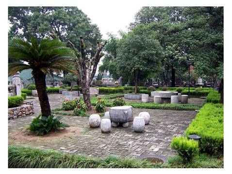
These three Han relics are associated with Hanzhong and have present day sites near the Hantai where they are said to have existed at the time of Liu Bang's presence in Nanzheng. The ancient Hantai has been discussed in the text. The Alter for Conferring Titles is located in the northern part of Hanzhong city. It was originally built as the site where Liu Bang made Han Xin the Major General in charge of his conquest of the Three Qin. The Alter was built at the instigation of Xiao He in order to win the complete commitment of Han Xin and reinforce his prestige. This history is described in the "Records of the Grand Historian" (Reference 3). The Pool for Watering Horses is Hanzhong’s "East Lake" and lies several hundred metres to the north-east of the Hantai. It is reputed to be where Liu Bang’s troops did, in fact, water their horses. Today it is a pleasant garden and large pool with a three storied Pagoda.
[7] Major Buildings at the Hanzhong Museum
The Wangjiang Building and the Guiyin Hall are large Northern Song and Qing period buildings at the site of the Hantai where the Hanzhong Museum is located. They are historical relics of great importance and are in excellent condition. They are used as centre pieces for the Museum display and functioning.
[8] Stone Inscriptions at the Hanzhong Museum
There are a number of very famous stone inscriptions rated as major advances in the history of calligraphy that are preserved and on display at the Hanzhong Museum. "Gun Xue" was supposedly done by Cao Cao (Wei Wudi) to describe the view from the top of the Chicken Head Pass where the Stone Gate tunnel is located. "Stone Gate" is an inscription preserved by moving it from the flooded area of the Stone Gate pass. "Jade Basin" is an ancient description of the riches of Hanzhong and some say the original was done by Zhang Liang. "Stone Tiger" is Han period calligraphy of great antiquity referring to the Stone Tiger Peak, a mountain near the entrance to the Baoxie road. Many pieces of cultural value were preserved when the Stone Gate Reservoir had its volume increased in 1971 resulting in the flooding of the Stone Gate tunnel and the associated inscriptions. The "13 Treasures" that were rescued are on display at the Hanzhong Museum.
9 Appendix 2: Chinese Text for the Preface
汉中博物馆, 冯岁平 编著, 三秦出版社, 2003年 序言
汉中,这个位居秦巴腹的地方,并不这么起眼, 甚至一时在地图中很难找到它的准确位置,旦它确拥有极高的知名度。不光这里拥有独特而优起的自然条件,长期以来所享有之 "西北小江南"、"陕西鱼米之乡"的美誉传扬四方,而且在中华民族几千年中,这个特殊历史大舞台,还演义、发生着太多太多人感怀的千古旧事。
"明修栈道,暗度陈仓"、萧何月下追韩信、创乱世太平的五头米道、 "鞠躬尽瘁,死而后己"以及"铁马秋风大散关" 等等,妇孺皆知,耳熟能详,从而在历史流程之中留下子一笔笔浓抹重彩。
汉中的悠久历史还不止于这些。作为国家级历史文化多城,汉中拥有无比深厚的历史文化资源,石器时代的李家村文化,殷商城洋青铜器及宝山遗址,汉代的张良庙、张骞墓、李固墓、蔡伦墓,三国的武侯墓、武侯祠,等等,不一而足。在这些物化的历史文化遗存中,位居汉中城心脏部位之"汉初三遗址"一古汉台、拜将台和饮马池,恐怕是最负盛名的名胜古迹, 尤其是古汉台,蔚为这座历史文化名城的名片,架起连接古今历史文化的桥梁。
1959年,以古汉台为馆址建成了汉中博物馆,经过45年不懈努力与有序发展, 该馆已座成为一座综合性的地方历史博物馆和遗址性博物馆,跃居"陕西十大博物馆"之列。如今,当您身临其境时,真有种如行花簇地,步步皆芬芳的感觉。其中望江楼、桂荫堂与"衮雪"、"石门"、"玉盆"以及"石马" 等,已成为汉中父老乡亲乐于使用的标志足和名牌, 广泛应用于各行各业中。
本书向您叙说的,就是古汉台悠久的历史、以此为馆址的汉中博物馆之概貌, 还有更多有关汉中历文化的信息。
10 Appendix 3: Chinese text for the description of the Exhibition Hall
汉中博物馆, 冯岁平 编著, 三秦出版社, 2003年, 二十五页
褒斜古栈道陈列室
人类在发展过程中,后人有时不得不叹服先辈们的聪明与智慧,当时那么落后,怎么就能有令人扼腕称赞的壮举,以至来世无法完全掌握其准确的历史信息。褒斜古栈道就是这样的一个例子。
汉中,前已有述,它北有秦岭屏障,南有巴山险阻,是一个相对封闭的地理单元。先民们不断开拓,经过无数次踏勘之后,在秦巴两大山地之间,开辟了数条交通道路,它们分别是穿越秦岭的子午道、漟骆道、褒斜道和故道(陈仓道),逾越大巴山的金牛道、米仓道和洋巴小道。这些道路就是人们常说的蜀道。
顾名思义,褒斜道是沿着褒水(今褒河)和斜水(今石头河)所形成的一条道路。先民们经过无数次踏勘,终于沿褒斜二水寻找到高峻入云的秦岭主脊较为平缓的一段,即太白县五里坡,沟通了南北。走的人多了,便成了路。褒斜道北起眉县斜谷口,南至汉中城北褒谷口,全长235公里,是秦岭间出现最早的一条交通大动脉,它也以其成道之早、持续之久、规模之大,在诸条蜀道之中最负盛名。历代屡废屡兴不断修筑所反映的积极进取、不断开拓的栈道精神,已成为汉中人民全面建设小康社会的一笔重要的历史文化财富。
褒斜古栈道陈列室是汉中市博物馆业务人员,在数次实地踏勘和深入研究的基础上完成的。随着时间的推移,这种研究的深入与广泛程度与日俱增。2002年,该馆在原陈列室的基础上又进行了改造。让我们一起参观一下这个陈列室。
第一单元 千回万曲,古道悠悠 -- 褒斜古道的由来
世上本来没有路,走的人多了便成了路。褒斜道是人猿担别之后先民渴望认识外部世界,沿着褒斜二水经过无数次踏勘形成的。您从梁山石器、城洋青铜器可以追溯这种悠久的历史。对于这条道路,历代文献记载亦层出不穷,出现了许多富有传奇色彩的故事或历史。这些故事有三皇祗车出谷口、武王伐纣蜀为盟、烽火戏诸侯、秦厉公城南郑、五丁开道和火烧栈道等。在这里,通过现代绘画,您更可加深对褒斜遥远久历史的认识; 在这里, 您可以领略褒斜道在栈道出现之前的历史及其来龙去脉。
第二单元 桥阁横空, 飞腾绝壁 -- 褒斜栈道的修建
约在战国中后期,铁器普遍使用之后,褒斜道沿途出现了栈道,"栈道千里,无所不通,惟褒斜绾毂其口"。汉武帝时,数万人对其进行大规模修筑。自此而后,历代累加修整,使其始终维持着南北交通之畅达,成为穿越秦岭的一条交通大动脉。北魏之后,栈道逐渐被碥道替代,民国时改造为宝汉公路,但褒斜古栈道巨大的工程、艰难的施工、完善的设施,在古代交通史上号称奇迹之一。
栈道,又名阁道、栈阁、桥阁,是古代劳动人民在山地地貌状态下因地制宜创造的一种道路形制。一般来说,修建的栈道由壁孔与横梁、柱孔与立柱、木板等构成,即先在悬崖峭壁间凿孔安柱, 架桥连阁,从而成为一种悬空式道路。它像一条巨龙蜿蜒于深山幽谷之中。考古工作者根据实地考察结果,用模型的形式展现了栈道的不同形制。
根据建筑方式,栈道可分为标准式、依坡搭架式、千梁无柱式、 石积式、多层平梁式和凹槽式等。标准式是在峭壁间凿方孔,横加木板,并在其下河底岩石上凿孔,安插立柱,然后在横梁上铺就木板成道。留坝县阎王碥、石门隧道南北,即有这种栈道分布。依坡搭架式,与标准式不同的是,其下方柱孔选择在山坡间,犹如搭起的木架般,故名。千梁无柱式,则多建在悬崖峭壁、河水太深,由于架设的栈道过高,无法安插立柱,于是加密栈道壁孔,增加承载力。
石积式, 《石门颂》记载有"造作石积,万世之基",它是用石料累积而成。在栈道沿途,往往高出路面的小山嘴等,先民们将其凿下,形成凹槽式通道。而最为复杂的栈道形制是多层平梁式,它多分布在高峻的悬崖峭壁间,将单层横梁改变为多层平梁,用立柱来衔接上下平梁,从而形成了这种楼道形制。四川广元市朝天区明月峡楼道,即属此类栈道,今已开辟为旅游风景区,成为国家级风景名胜区 -- 剑阁蜀道风景区的重要景点之一。一般来讲,河流下游的栈道高于河面5-8米,上游约3-4米,而且并非所有路段都是栈道,褒斜古栈道只有大约2/3路段才架设有栈道。当然栈道的质地有木栈、石栈两种,越到后代,石栈所占的比例就越多。这些栈道是古人不断尝试、总结出来的,反映了我们祖先的聪明才智,同时也是不断开拓、积极进取精神之实物见证。
古褒斜道最值得后人传颂的是世界上最早的人工穿山交通隧道 -- 石门。面对陡峭的鸡头关,先民们排除万难,在东汉永平年间, 汉明帝诏令修复褒斜道时,开通了石门隧道。《石门颂》记载: "至于永平,其有四年,诏书开斜,凿通石门"。
据解放后的实地调查,石门略呈南北向,基本与褒河河谷平行,其基面与南北栈道处于同一水平线上,说明南北贯通,平坦易行。而石门东西两壁因山嘴长短不一而略有不同,其中东壁长 16.5 米,西壁长 15 米,南口高 3.45 米,宽 4.2 米,北口高 3.75 米,宽 4.1 米。按照汉代通行的定制,石门洞内可容两辆车并行或相向而行。石门的开通,极大便利了南北往来,使褒斜道七盘山段大为改观,来往行旅称便。北魏《石门铭》说: "穹隆高阁,有车辚辚,成夷石道,驷牡其骃,千载绝轨,百辆更新"。尽现昔日褒斜道石门通车的盛况。
石门这项著名的穿山工程,是怎么开凿的? 据文物工作者调查,石门洞内岩石裸露,石质非常坚硬,表面略有起伏,但又光平齐整,并无人工斧凿的明显痕迹。清代贾汉复《修栈道歌》有云: "积薪一炬石为坼,锤凿即加如腐削", 似乎说明石门是东汉时用火烧水激的办法开凿的。但这种说法一经仔细琢磨,则疑窦丛生。
洞内历代留有42种石刻,若果如此,那么石刻表面必定受到火烧水激的影响,年代久远,势必洞内岩石石质松散,随之石刻表面漫漶,甚至剥落殊甚。而且自宋而后的数百年间捶拓磨损,很难想象现在石刻表面残泐的状况。
当走进陈列室摩挲观赏原刻时,您就会发现《石门颂》、《石门铭》等石刻,除长期捶拓留下的浓浓的墨迹外,其表面石质完整,丝毫无缺,连众多学者对保护如此之好、字迹如此之清而大加赞赏。因此,用火烧水激办法开凿石门之说,实在难圆其说。现在看来,当时尚无现代化的爆破技术,又无钢钎等现代开凿工具,石门隧道究竟是怎样开通的? 这仍是尚待解开的千古之谜。
第三单元 蜀道秦关,天险通途 -- 褒斜栈道的交通
本单元依次分为交通工具、邮亭驿站和古栈咏颂三部分,反映了褒斜道是交通之道,是自古以来穿越秦岭的一条交通大动脉,它还是一条文化之道。您在这里可以领略到不同时期各种形制的交通工具,号称天下第一驿的唐代褒城驿,以及蔚为大观的诗歌作品、摩崖碑碣和栈道画卷.....
翻开中国古典文献,您可不时地看到有关褒斜道的记述"贱避贵,少避长,轻避重,去避来", 南宋《仪制令》碑(现存今略阳灵岩寺)成为我国现存最早的交通规则之实物标本。"严秦修此驿,水涨驿前池。已种万竿竹,又栽千树梨。四年三月半,新笋晚花时,怅望东山去,等闲题作诗"。唐代元稹《褒城驿》诗,让人们领略到"天下第一驿" -- 亵城驿的无限美景。
其实,您只要略作翻阅,就会发现许多文人墨客曾取道褒斜道,穿梭在秦巴之间,出入于关中与四川盆地之间,如清代神韵派诗人王渔洋,康熙年间曾三次履栈,性灵派诗人张问陶,乾嘉时期曾六次历经。清代诗歌史的两大流派扛鼎人物,前后取道连云栈,并丰富了他们的诗歌创作,这是独特的栈道文化现象之一。明代著名地理学家王士性《入蜀稿》和《入蜀记》、王渔洋《蜀道驿程记》和《秦蜀驿程记》、张邦伸《云栈纪程》、陈奕禧《益州于役志》、陶澍《使蜀日记》、张素含《蜀程纪略》、王志沂《汉南游草》、俞平伯之父俞陛云《蜀輶诗记》、日本著名汉学家竹添井井《栈云峡雨日记》等等,连续注释着蜀道历史的辉煌,印证着一个个古老的故事。
古老的褒斜栈道,承担着历史,运载着今天,延伸着未来。我们在叹服古人聪明智慧的同时,也不得不感慨现代社会发展之快。 如此复杂的褒斜道及古栈道,今天在科研人员和能工巧匠的辛勤努力下,一一直观而形象地展示出来,成为面向全社会特别是青少年进行爱国主义教育的好素材。 |