|
Outcome Documents, References and Materials: Shu Roads Field Study, June 2012
This page collects documents and materials arising from or relating to the Shu Roads between Chengdu and Hanzhong that were visited
during field work in June 2012. The "General Material and Maps" collected below was generated prior to the field work and, where necessary,
revised or corrected following the visit.
In June 2012, David Jupp, Feng Suiping (Director of the Hanzhong City Museum) and other Hanzhong Museum Staff travelled from Chengdu to
Hanzhong and later from Hanzhong to Xixiang and Chenggu investigating Shu Road relics and also checking the current situation as it compared with that
reported in 1868 by an English traveller, Alexander Wylie. Along the way, information from a set of Qing Period maps was also investigated in the field.
The documents and reports that have arisen since and present the findings of the visit are now collected on this page.
Many of the documents are still to be regarded as drafts and treated as such. Comments, corrections and questions are welcome :)
|
Document or Item
|
Description
|
File Name (or Link)
|
Size
|
|
1
|
Materials used in the field study
(该研究的相关地图和资料).
Primary Description of the Information that was available for the field work and subsequent reports.
In particular, it is a basic reference for the new documents and outcomes arising from the field visit in June 2012.
It includes (1) a discussion of the Shu Roads and early motor roads that replaced them. This includes information provided by foreign
travellers in the late Qing and Republican times, information from Qing period maps and a description of the Google Earth
presentation of the Shu Roads. (2) Mosaics based on Russian Topographic Maps. This includes a general discussion of the Russian maps,
information on the maps now held by the project, example mosaics as Google Earth presentations and a discussion of the Russian
Palladius system for transliterating Chinese to Russian.
A Palladius to Pinyin Table has been developed to enable the map names to be interpreted in Chinese Pinyin. It is included here
as part of (2) and as a separate PDF document File (3).
|
(1).Using_Maps_and_GPS_to_find_Shu_Roads.pdf
(2).Russian_Mosaics_Info.pdf
(3).Cyrillic_Pinyin_Table.pdf
|
1.6Mb
801kb
342kb
|
|
2
|
Alexander Wylie's journey from Chengdu to Hankou via Hanzhong by road and boat in 1868.
Four documents covering this important journey and its description as originally presented by Paper and discussion to the Royal Geographical Society of London in 1869/70.
(1). A draft discussion by David Jupp (2012) introducing the background, context and present relevance of the paper. It includes findings and materials obtained during the Field Visit in June 2012.
(2). A table of Qing Period Places on the road between Chengdu and Hanzhong and between Hanzhong and Shiquan via Xixiang listed by Wylie and their modern Chinese equivalents found in modern maps
and by field work in June 2012. Used to update the Shu Roads Google Earth presentation.
(3). A table relating Wylie's pre-Wade-Giles transliteration with modern Pinyin to help in further investigations.
(4). A copy of the original Paper by Alexander Wylie (published 1869) describing the Jinniu Road (a Shu Road) and Han River in "Proceedings of the Royal Geographical Society of London".
|
(1). Alexander_Wylie.pdf
(2). Alexander_Wylie_Itinerary_update.pdf
(3). transliteration_table.pdf
(4). Wylie_1870_1799562.pdf
|
530kb
189kb
124kb
936kb
|
|
3
|
The Linking Road from Shiquan to Hanzhong via Xixiang. This road was followed and described by Alexander Wylie in 1868 and by Sir Eric Teichman in 1917. The road passes through Guluba where
Italian Missionaries opened a mission station in the late Qing and where early Roman Catholic missionaries and local Christians had built a church many years before. This document includes
field notes (main source for field notes on this part of the field visit), photographs and Google Earth images showing the GPS tracks travelled and places visited.
It includes a visit to the Cailing Mosque at Shahe Kan (西乡县沙河坎蔡岭寺).
This road was an important route to bypass dangerous rapids during the trade that came to Hanzhong and beyond via the Han River
and has always been an important linking road between all directions from the Hanzhong Basin.
|
Xixiang_road_Hanzhong_to_Shiquan.pdf
|
2.3MB
|
|
4
|
History of visits to the Shu Roads and Hanzhong by Catholic Missionaries.
This document was suggested by the visit to Guluba (
古路坝
) in Chenggu County (
城固县
) on the linking road between Hanzhong and Shiquan. In the past there had been both an Italian Mission and a wartime Chinese
University at Guluba. It also seemed that there had been a long history of visits to the
Hanzhong area by Catholic Priests, dating back to the 17th Century. A
study was therefore undertaken to identify some of these traveller missionaries and to record
the history of their secular involvement with Hanzhong, Guluba and the Shu Roads.
|
Catholic Missionaries on the Shu Roads
|
1.1MB
|
|
5
|
Two Google Earth Photo-Hikes to ancient passes on the Shu Roads.
Shu Roads Google Earth (GE) KMZ files of Photo-presentations
of two field visits to sections of the old Shu road (pre-motor road). One is at Tianxiong Pass in Sichuan and the other is at
Jitou (Chicken Head) Pass at the Stone Gate near Hanzhong. The visits inspected the state of Shu Road relics and made records. The
Tianxiong Pass still has damage that occurred during the Sichuan 512 Earthquake in 2008. There are two KMZ files in the one zip file.
(See also GPS Web Page HERE)
|
Jitou_Tianxiong_Web_Link
|
3kb
|
|
6
|
Scanned plates and maps from old books by western travellers on the Shu Roads.
A number of old and some first edition books have been acquired that were published by western travellers on the shu roads.
A collection of scans of some relevant plates and maps is available in a table for inspection of quality and value.
The quality may be improved in some cases with software. For this reason the images are provided
with high resolution. The site is here for download and discussion. Other similar plates and maps
may be provided if there is interest.
|
List of Plates scanned from old books
|
3kb
|
|
7
|
Two documents discussing questions remaining about the northern plank road between Hanzhong and Baoji.
The field work planned for this section of the visit was (unfortunately) shortened, but it still enabled useul checks of place names,
GPS coordinates and some other questions.
These two documents outlining unresolved questions have been provided as they may best be answered by interested readers and (if not) will be pursued in the next visit. They are (1).
A discussion about Barrier Posts and District boundaries on the Library of Congress
Qing Period Scroll Map
(developed before the field visit in June 2012) and (2).
A discussion on an anomalous border between Nanzheng and Liuba Counties written in September 2012 and revised in December 2012 with a translation of additional information.
You are welcome to read, consider and contribute to the debate!
|
(1). Garrison_Barriers_on_the_Plank_Road.pdf
(2). Anomaly_in_the_Qing_Scroll_Map.pdf
|
81kb
600kb
|
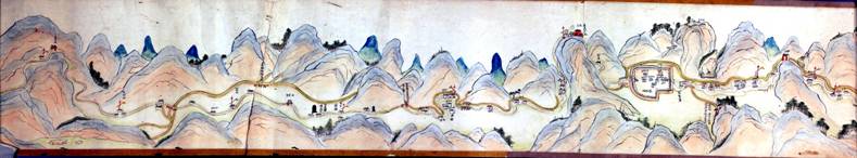
The following Table presents material collated to support the field visit in the form of maps and links for easy access to important background material.
It was available on this web site during the field visit for remote access when that was possible.
The main materials are well resolved presentations of a Qing Period Scroll Map of the road from Baoji to the Sichuan border in Shaanxi, a set of mosaics of Russian Topographic Maps
developed before much modern infrastructure replaced ancient sites, and access to the Shu Roads Google Earth presentation. The translations into Chinese
by Jiang Qian (姜茜 Jesse),
were provided to help Chinese field staff navigate the collection. The images and maps are valuable material and have within them many questions awaiting answers and answers awaiting questions!
|
Reference
|
General Material and Maps
基本数据与地图
|
File Name (or Link)
|
Size
|
|
8
|
PDF Documents for high-resolution Sub-Images of the scroll map (I)
地图卷上高清晰度的子图像的 PDF文件(1.)
|
Jpegs_Baoji_Wuguan_1_12.pdf
|
2.8MB
|
|
9
|
PDF Documents for high-resolution Sub-Images of the scroll map (II)
地图卷上高清晰度的子图像的 PDF文件 (2.)
|
Jpegs_Wuguanyi_Jitouguan_13_24.pdf
|
2.8MB
|
|
10
|
PDF Documents for high-resolution Sub-Images of the scroll map (III)
地图卷上高清晰度的子图像的 PDF文件(3.)
|
Jpegs_Jitouguan_QipanGuan_25_35.pdf
|
2.3MB
|
|
11
|
Web Page for information about the Library of Congress (LOC) Scroll Map
关于国会图书馆地图卷的网页
|
LOC_Scroll_Web_Page
|
Link
|
|
12
|
Web access to a Table listing the 35 high resolution Jpegs
of the Qing Period LOC Scroll Map. Images are on average 3 MB each but can be viewed online with Broadband.
上网可以查看到这个清朝时期的LOC地图卷,一共是35张高清晰的图片。 每张图平均是3Mb大小,可以宽带网上浏览。
|
Table of high Resolution Images
|
Link
|
|
13
|
Shu Roads Google Earth (GE) KMZ files of presentations (documentation and
three KMZ in zip file) (See also GPS Web Page HERE)
演示用的蜀道Google Earth (GE) KMZ格式文件包(包括了文档和3个KMZ文件的压缩文件) (见这里GPS网站
这里)
|
GE_KMZ_Files_Shu_Roads
|
1.39MB
|
|
14
|
Russian Topographic Maps GE KMZ Mosaics for main Shu Road area (three KMZ files in
one zip file) (See also GPS Web Page HERE)
显示主要蜀道地区的俄罗斯的地貌地图(为GE KMZ格式。是一个包含3个KMZ文件的压缩文件) (见这里GPS网站
这里)
|
GE_KMZ_Russian_Topo_Maps_Mosaics
|
4kb
|
|
15
|
QuickLook (Low Resolution) Jpeg images for the Russian Topographic Maps of the main Shu Road area
使用低解析度的JPEG图像显示的主要蜀道地区的俄罗斯的地貌地图
|
List_Russian_Mosaics_Qlooks
|
Link
|
|