Google Earth KMZ Presentations for Martino Martini and Kangxi Jesuit Maps
Jesuit Cartographers in China
|
Google Earth KMZ Presentations for Martino Martini and Kangxi Jesuit Maps
Jesuit Cartographers in China |
From 1710 to 1720, French Jesuit mathematicians and
cartographers carried out a survey of the realms of the Kangxi Emperor of China. The result was a detailed and
cartographically quite accurate map covering East Asia. While the Chinese map was kept secret, the Brothers sent copies of
the map(s) back to Europe where Jean Baptiste Bourguignon d’Anville published the maps based on them in 1735. These maps were
the basis for European maps of inland China until after the Opium Wars in 1860.
Web Page for more information: Kangxi_Jesuit_Maps
Martino Martini was an earlier Jesuit brother in China
whose geographic and cartographic information was brought to Europe in 1655 and published by the map maker Johannes Blau.
His Atlas remained the main source of information for Europe until the Kangxi maps more than 50 years later. The gazetteer
and its local information was still relevant even after the new maps were published.
Web Page for more information: Kangxi_Jesuit_Maps
The maps of the Jesuit Brothers can be displayed in Google
Earth for convenient view and analysis. The presentations on this page have been discussed in two published papers. The
first was published in Cartographica concerning the Kangxi Maps:
Jupp, David L.B. (2017). Projection, Scale, and Accuracy in the 1721 Kangxi Maps. Cartographica, 52(3),
215-232. (DOI:10.3138/cart.52.3.2016-0004) If your interest
is personal research and not for profit the paper can be accessed HERE.
A related paper concerns the d'Anville European maps and
the Martini Maps:
Jupp, David L.B. (2018). Determining projection and scale for maps in early atlases of China held by the National Library
of Australia. Journal of the Australian and New Zealand Map Society Inc., 84, 1-24.
If your interest is personal research and not for profit the paper can be accessed HERE
The Table below contains six Google Earth compatible KMZ files showing maps. They allow a number of the Martini and d’Anville maps to be displayed in Google Earth and compared with each other and assessed for accuracy. There are also two KMZ files with 162 Fu (first level Provincial cities) level places from the Martini and du Halde Gazetteers. These can be plotted with the relevant maps to assess plotting accuracy.
|
Link or Presentation |
Description |
|
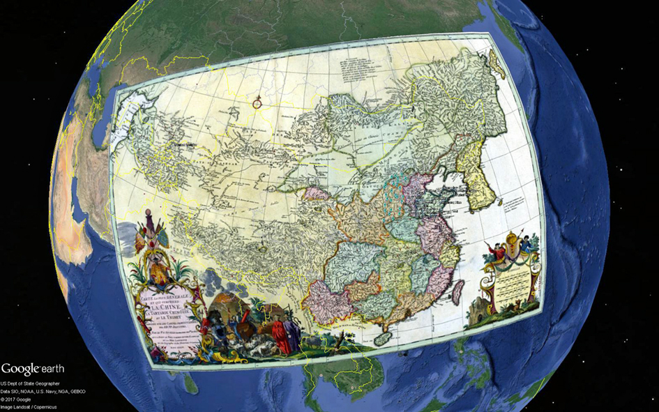
D’Anville’s general map of central and East Asia with all of the areas surveyed by the Jesuit Brothers included. It is a two-parallel conic projection and includes Russian material from the Bearing Strait and central Asia. It uses place names in the Jesuit transliteration. |
|
|
D’Anville’s copied map of Chen Si province. At the time, this province comprised parts of four of today’s Provinces: Shaanxi, Gansu, Ningxia and some in Qinghai. Original sinusoidal projection. |
|
|
Map of Chen Si produced by the Jesuit Brothers in China and updated in 1721. The maps were printed in China as woodblock prints. Shows Chen Si in original accuracy. Names of places in Chinese. This was likely base material for final maps. |
|
|
Contains 162 places at Fu Level from du Halde Gazetteer with names in the du Halde and Jesuit Brothers transliteration. Compare with Kangxi and d'Anville's maps. |
|
|
Martini Map 1655 of the 15 Provinces of Ming China. Projection is conic with two parallels. Place names in the Martini transliteration. |
|
|
Martini Map of the Chan Si province (present Shaanxi, Gasu, Ningxia and part of Qinghai) called Xensi in the Martini transliteration. Has representation of the Main Post road (Northern Plank Road) between Xi'an (Sigan) and Hanzhong (Hanchung) |
|
|
Contains 162 places at Fu Level from Martini Gazetteer with names in the Martini transliteration of the Chinese. Compare with Martini Maps. There are significant distortions in the Martini maps compared with the Kangxi maps. |
|
|
The complete 1721 Mosaic of 15 Provinces for reference and comparison. Assembled by David Jupp from individual Province maps from the Library of Congress image collection. Projection was sinusoidal with Beijing as prime meridian and place names in Chinese. |
The Maps are all stored at a remote web area and accessed by a Network Link. Sometimes it is slow to load – especially when accessed for the first time. As the cache builds up the access is faster. This allows the KMZ file to be small and if any revisions are made to the presentation there is no need for users to update the KMZ file - perhaps refresh or reset the cache at most.
The presentation (KMZ) and other files on this page can also be downloaded as a ZIP file (4 MB) HERE.
Questions can be addressed to: David Jupp (Email):dlbjupp@ozemail.com.au.